
The best camping trips are the ones where technology enhances the experience without replacing it. The right apps help you discover hidden campsites on private ranches, navigate backcountry trails without cell service, identify that bird singing at sunrise, reserve the perfect National Park campsite months in advance, and share your GPS coordinates with family so they know you are safe. In 2026, outdoor apps have evolved from basic GPS tools into comprehensive adventure companions powered by AI, augmented reality, and massive community databases.
This guide reviews 12 of the best camping apps for outdoor adventures in 2026, covering trail navigation, campsite discovery, nature identification, safety communication, and trip planning. Whether you are a weekend car camper, a backcountry backpacker, or a cross-country overlander, these apps will elevate every outdoor experience. For more outdoor and lifestyle recommendations, explore our guides on van life navigation apps, campground and RV park finder apps, battery optimization apps, international travel apps, and health and fitness apps.
Table of Contents
- AllTrails (Rating 4.9)
- Recreation.gov (Rating 4.9)
- Merlin Bird ID (Rating 4.9)
- Hipcamp (Rating 4.8)
- FarOut (Rating 4.8)
- The Dyrt (Rating 4.8)
- Gaia GPS (Rating 4.8)
- onX Backcountry (Rating 4.7)
- Komoot (Rating 4.7)
- PeakVisor (Rating 4.6)
- iNaturalist (Rating 4.6)
- Cairn (Rating 4.5)
- Which Apps Should You Pack?
- Outdoor Camping App Tips
- Frequently Asked Questions
1. AllTrails (Rating 4.9)
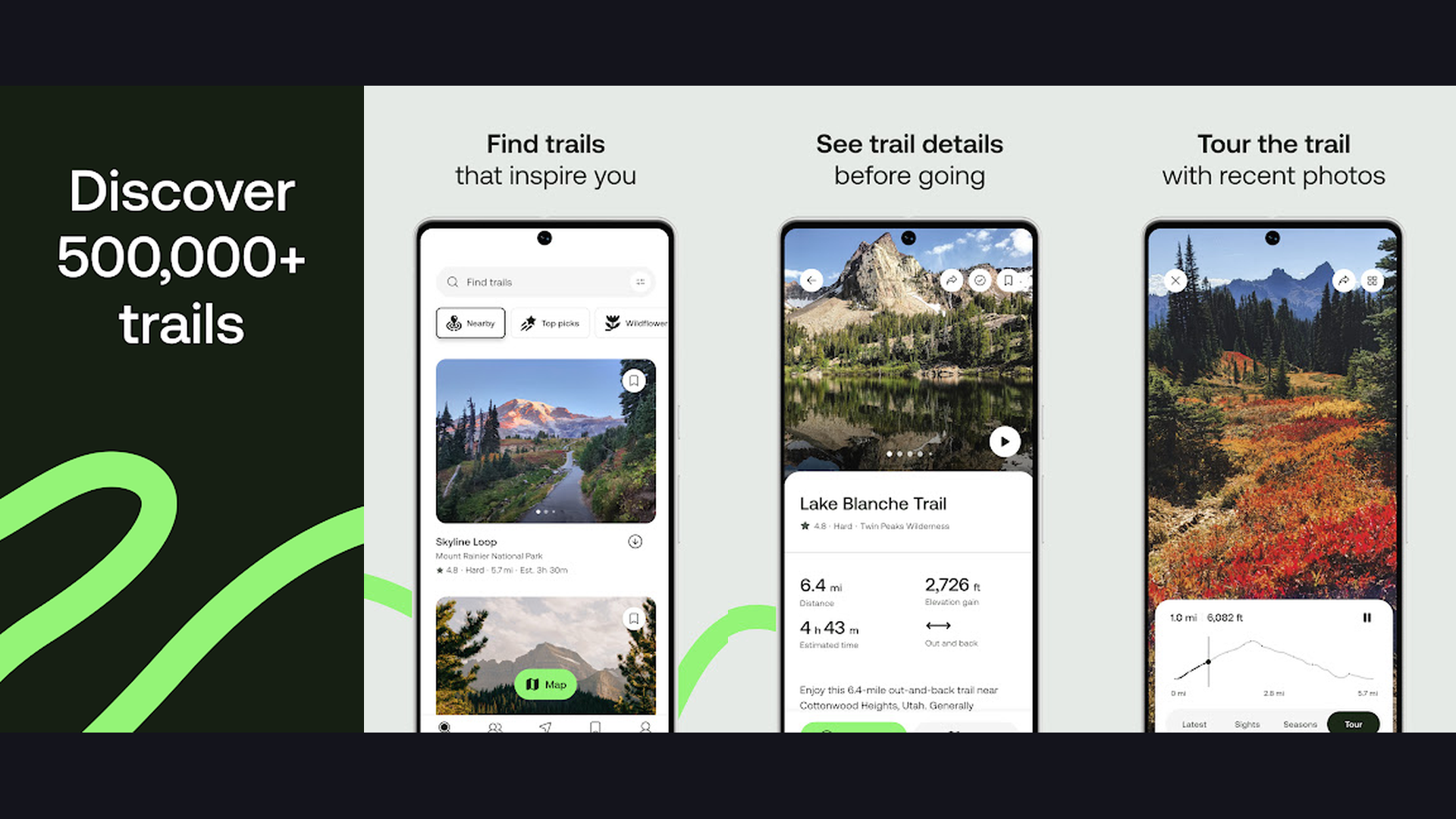
AllTrails is the most popular trail discovery app in the world with over 400,000 curated trails across 150+ countries, featuring GPS navigation, offline maps, trail reviews with photos, elevation profiles, difficulty ratings, and AI-powered route planning for hikers, bikers, and trail runners. AllTrails transforms campsite explorations into guided adventures. The trail database is the most comprehensive available, covering hiking, mountain biking, running, and walking trails with detailed information: distance, elevation gain, route type (loop, out-and-back, point-to-point), difficulty rating, and estimated completion time. The community-driven reviews include condition reports, photos, and tips from millions of active users. The offline maps download entire trail regions for navigation where cell service drops to zero. The GPS tracking records your route in real-time with breadcrumb trails and automatic off-trail alerts. The AllTrails+ subscription adds AI-powered trail recommendations, weather-based trail suggestions, and 3D previews. The Lifeline safety feature shares your real-time GPS position with emergency contacts. AllTrails costs free with AllTrails+ from $35.99/year. For outdoor enthusiasts wanting the best trail discovery and navigation, AllTrails is the starting point. Find more outdoor tools with van life navigation apps.


2. Recreation.gov (Rating 4.9)
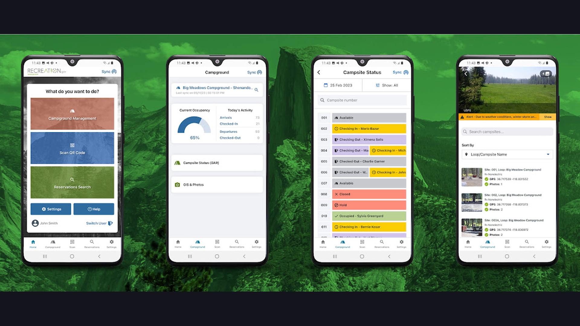
Recreation.gov is the official U.S. government app for reserving campsites, day-use permits, tours, and activity tickets across National Parks, National Forests, Army Corps of Engineers lakes, Bureau of Land Management areas, and other federal recreation lands. Recreation.gov is the only authorized booking platform for federal recreation sites, making it essential for camping in Americas most iconic outdoor destinations. The campsite reservation system covers thousands of campgrounds across Yellowstone, Yosemite, Grand Canyon, Great Smoky Mountains, Glacier, and hundreds more. The permit system handles wilderness permits, entrance passes, and popular lottery-based permits (Half Dome, The Wave, Enchantments). The day-use booking covers picnic areas, swimming beaches, boat launches, and group pavilions. The tour booking includes guided cave tours, historical site visits, and ranger-led programs. The search filters by location, date, campsite type (tent, RV, cabin, yurt), amenities, and accessibility. The availability alerts notify you when sold-out sites have cancellations. Recreation.gov is free (booking fees apply per reservation). For camping in U.S. National Parks and federal lands, Recreation.gov is mandatory. Plan federal land trips with campground finder apps.
3. Merlin Bird ID (Rating 4.9)
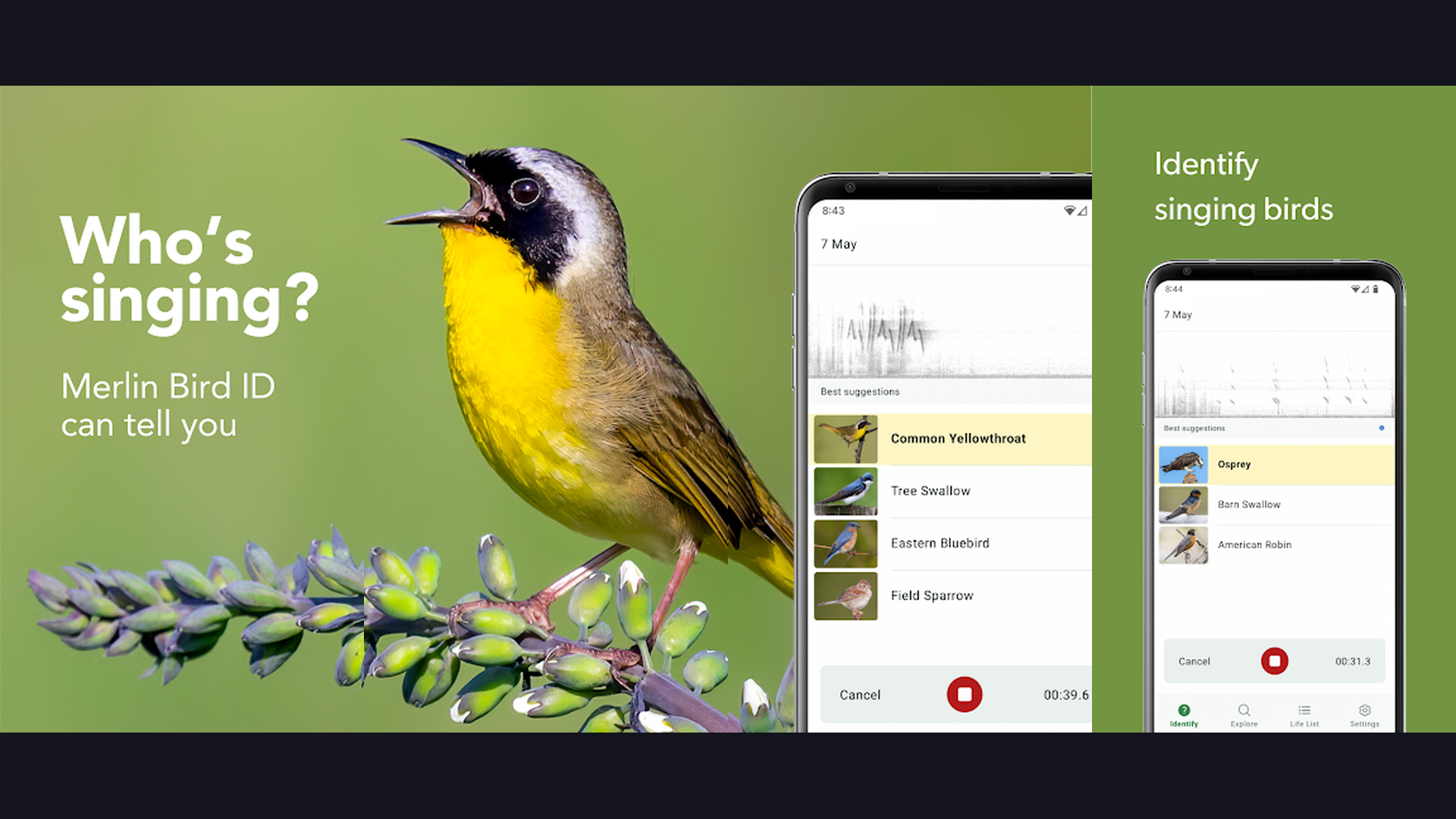
Merlin Bird ID by Cornell Lab of Ornithology is the most advanced free bird identification app, using AI-powered photo recognition, real-time sound identification that identifies birds singing around you, and step-by-step visual guides to identify over 10,000 species from around the world. Merlin transforms every camping trip into a birdwatching adventure. The Sound ID feature is genuinely magical: press record and Merlin listens to the birds singing around your campsite, displaying real-time identifications as a scrolling spectrogram with species names appearing as each bird calls. The Photo ID analyzes your bird photos and suggests matching species. The ID Wizard asks simple questions (location, date, size, color) and narrows down possibilities from thousands of species. The regional Bird Packs download offline databases for specific areas, including photos, songs, range maps, and descriptions. The species account pages include multiple photos showing male, female, and juvenile plumage. The life list tracks every species you have identified. Merlin is completely free (by Cornell Lab). For camping nature lovers who want to identify every bird singing at their campsite, Merlin is pure joy. Discover nature with entertainment apps.
4. Hipcamp (Rating 4.8)
Hipcamp is the Airbnb of camping, connecting outdoor adventurers with unique private land camping experiences including farms, ranches, vineyards, forests, and lakefront properties that offer privacy, natural beauty, and experiences far beyond what traditional campgrounds provide. Hipcamp has unlocked an entirely new category of outdoor experiences by enabling private landowners to list their properties as campsites. This means campers can access stunning locations that were previously inaccessible: a meadow on a working cattle ranch, a clearing in a private redwood forest, a lakeside spot on a family farm, or a desert plateau with panoramic mountain views. Each listing includes detailed descriptions, host reviews, photos, amenities (fire pit, picnic table, water access, toilet, shower), and clear driving directions. The booking system is straightforward with transparent pricing. The map search shows availability near your route. The filters cover camping style (tent, RV, cabin, glamping, treehouse), amenities, price range, pet-friendliness, and host response time. Many hosts offer add-on experiences like farm tours, horseback riding, or fishing. Hipcamp charges per-night booking fees (typically $20-80/night). For campers wanting private, unique outdoor experiences on private land, Hipcamp is transformative. Find unique stays with more camping apps.

5. FarOut (Rating 4.8)
FarOut (formerly Guthook Guides) is the essential app for long-distance trail hikers, providing highly detailed trail-specific offline guides for the Pacific Crest Trail, Appalachian Trail, Continental Divide Trail, Camino de Santiago, and 100+ other major trails with waypoints for water sources, campsites, shelters, resupply points, and real-time community comments on current conditions. FarOut is the gold standard for thru-hikers and long-distance backpackers. Each trail guide is meticulously mapped with thousands of waypoints marking every critical feature: reliable water sources (with seasonal notes), established campsites, tent sites, shelters and huts, road crossings, trailheads, resupply towns, and points of interest. The community comments section is where current hikers post real-time updates on water availability, snow conditions, trail closures, and other critical information. The elevation profiles show every climb and descent. The mileage calculator tracks distance between waypoints. All data works completely offline with no cell service required. FarOut offers individual trail guides from $5.99-$29.99. For anyone planning a thru-hike or long-distance backpacking trip, FarOut is absolutely essential. Plan your trek with travel apps.

6. The Dyrt (Rating 4.8)
The Dyrt is the largest campground discovery platform with over 55,000 campgrounds and 5 million reviews, offering free and dispersed camping locations, BLM and National Forest land boundaries, offline maps, campground booking, and the most active camping community in North America. The Dyrt functions as the TripAdvisor of camping with a review database that dwarfs competitors. The community reviews include photos, tips, and detailed information from real campers. The map displays public land boundaries (Bureau of Land Management, US Forest Service, National Park Service) so you can identify legal dispersed camping areas. The Pro subscription ($35.99/year) unlocks downloadable offline maps with public land layers, exclusive campground discounts (up to 40% off at 1,000+ campgrounds), and free camping location data. The filter system covers campground type, amenities, activities, price range, and pet-friendliness. The alerts feature notifies you when campsites at popular locations become available. The Trip Planner creates multi-stop itineraries with campground suggestions along your route. The Dyrt is free with Pro from $35.99/year. For campers wanting the most extensive campground database with dispersed camping, The Dyrt delivers. Browse campgrounds with campground apps.
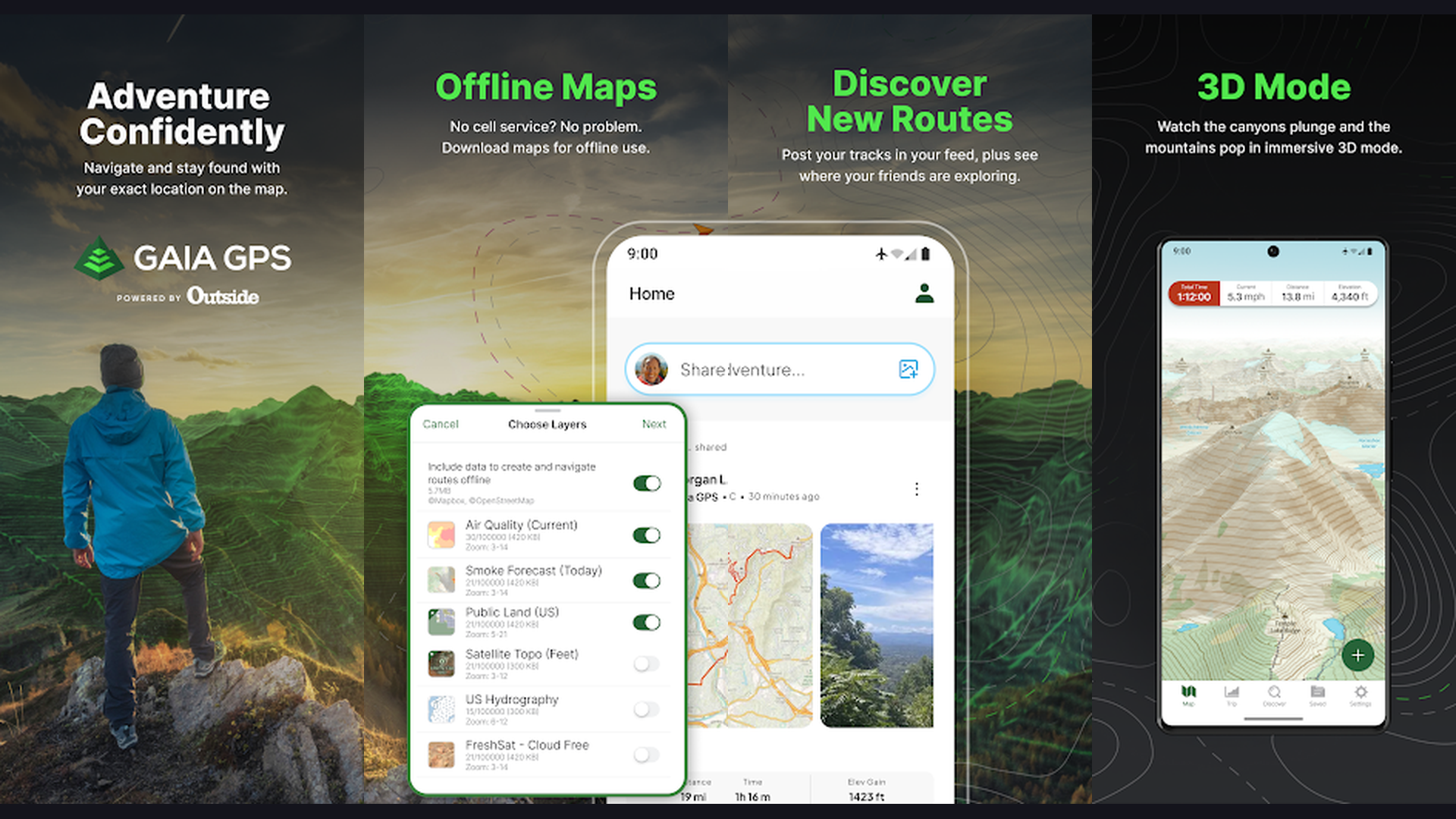
7. Gaia GPS (Rating 4.8)
Gaia GPS is the most advanced offline mapping and backcountry navigation app for serious outdoor enthusiasts, offering dozens of specialized map layers (topographic, satellite, public land boundaries, slope angle, weather), custom route planning, waypoint management, and the most detailed terrain visualization available on any mobile device. Gaia GPS is the professional-grade navigation tool for backcountry camping. The map layer system is unmatched: stack and switch between USGS topographic maps, satellite imagery, public land ownership boundaries, slope angle shading (for avalanche assessment), weather radar overlay, and dozens of specialty maps. The offline maps download entire regions at full detail for areas with zero cell coverage. The route planning tools create custom routes on trails or cross-country with elevation profiles, distance calculations, and estimated travel times. The waypoint system marks and categorizes locations (water sources, camp spots, viewpoints, hazards) with GPS coordinates. The track recording logs your movements for post-trip analysis. Gaia GPS is free with Premium from $39.99/year. For outdoor adventurers who explore remote backcountry and off-trail terrain, Gaia GPS is the ultimate navigation tool. Navigate off-grid with battery management.
8. onX Backcountry (Rating 4.7)
onX Backcountry is the premier GPS navigation and land information app for off-road, overlanding, and backcountry adventures, providing detailed topographic maps, private vs public land ownership boundaries, vehicle trail ratings, waypoint sharing, and real-time GPS tracking designed for adventures beyond established trails. onX Backcountry fills a critical gap between hiking apps and vehicle navigation by serving the overlanding, off-road, and backcountry driving community. The land ownership layers show exactly where public land (National Forest, BLM, state) ends and private land begins, preventing accidental trespass. The trail database includes difficulty ratings for vehicle trails (easy gravel to technical rock crawling). The offline maps cover entire states at topographic detail for areas with zero connectivity. The 3D map view provides terrain perspective for route planning through mountainous areas. The waypoint system lets you mark camp spots, obstacles, scenic viewpoints, water crossings, and share them with friends. The weather overlays show current and forecasted conditions along your route. onX Backcountry costs $29.99/year for Premium. For overlanders, off-roaders, and backcountry drivers, onX Backcountry is the specialized navigation solution. Explore off-road with navigation tools.
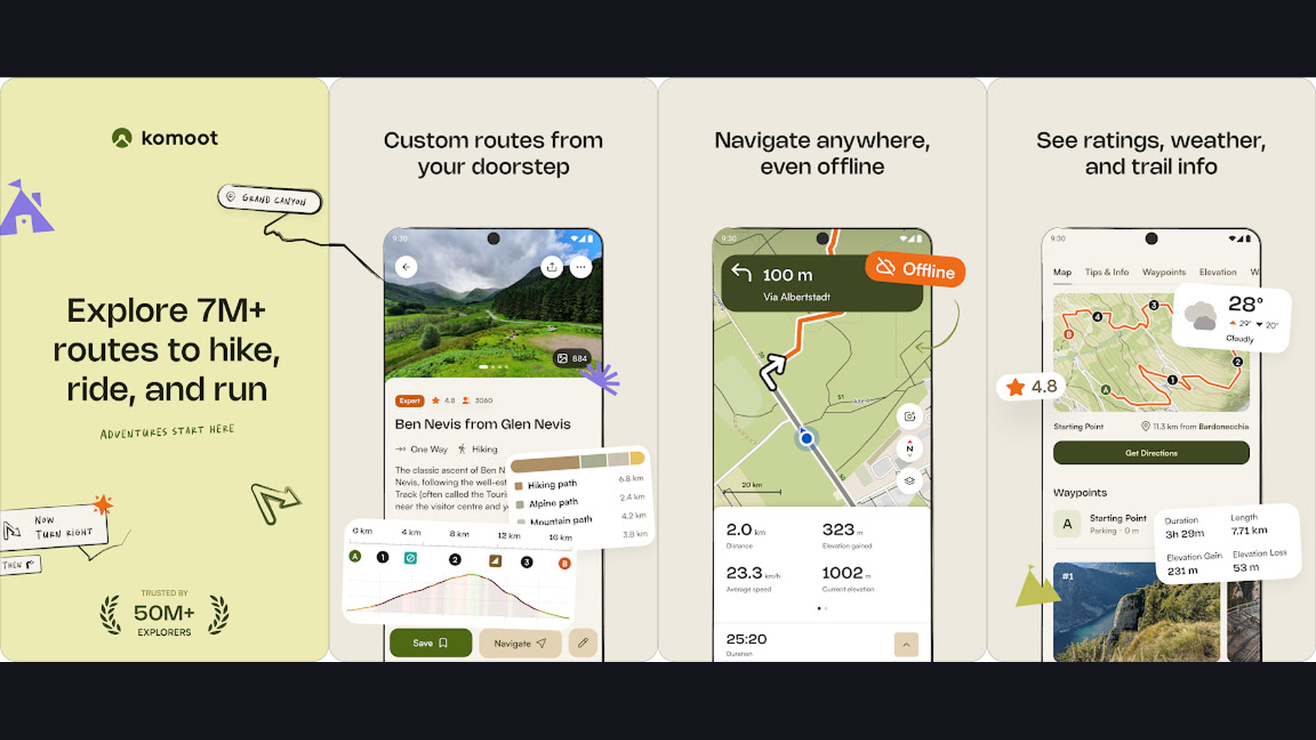
9. Komoot (Rating 4.7)
Komoot is the best multi-sport route planning app for outdoor adventures, offering intelligent route calculation based on fitness level, surface type, and elevation for hiking, road cycling, mountain biking, gravel riding, running, and ski touring with worldwide coverage and community-contributed highlights. Komoot stands out by providing sport-specific route optimization. Tell Komoot your activity type and fitness level, and it calculates routes that match your ability on appropriate surfaces. The route planner shows detailed elevation profiles, surface types (paved, gravel, singletrack, scramble), and estimated difficulty. The community Highlights are points of interest contributed by other users: viewpoints, swimming spots, rest areas, and recommended segments. The turn-by-turn voice navigation guides you without needing to stare at the screen. The offline maps download regions for areas without service. The integration with Garmin, Wahoo, and other GPS devices syncs routes directly to your cycling computer or GPS watch. The Collections feature curates multi-day itineraries with accommodation suggestions. Komoot offers one free region with Premium from $59.99/year. For outdoor adventurers who hike, bike, and run across varied terrain, Komoot provides the smartest routing. Track fitness with health apps.
10. PeakVisor (Rating 4.6)
PeakVisor is the most advanced augmented reality mountain identification app, using your phone camera to identify surrounding peaks, mountains, and terrain features in real-time with 3D panoramic maps, ski slope overlays, hiking route visualization, and sun position tracking for photography planning. PeakVisor adds an entirely new dimension to outdoor camping and hiking by turning every mountain view into an interactive identification experience. Point your camera at any mountain range and PeakVisor overlays peak names, elevations, and distances using augmented reality. The 3D map mode renders a photorealistic terrain model of your surroundings that you can rotate, zoom, and explore. The hiking route overlay shows nearby trails projected onto the 3D terrain. The sun position tracker shows sunrise and sunset angles for photography planning. The ski slope mode overlays piste maps for winter sports. The offline functionality downloads regional terrain data so the AR identification works without cell service. The telescope feature zooms into distant peaks with identification labels. PeakVisor costs $4.99/month or $19.99/year. For mountain campers and peak enthusiasts who want to identify every summit visible from their campsite, PeakVisor is magical. Capture peaks with photo editing apps.
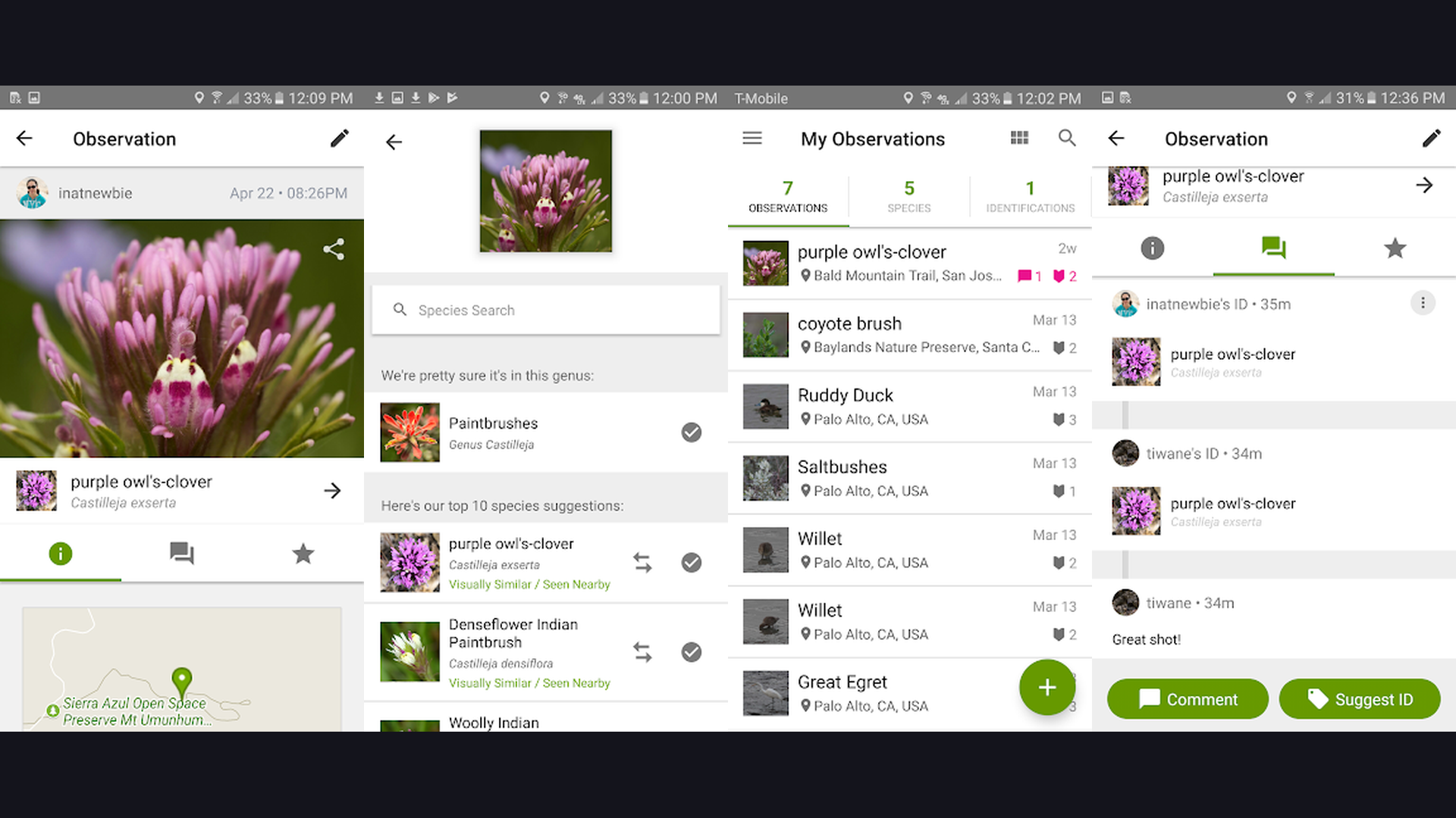
11. iNaturalist (Rating 4.6)
iNaturalist is the most comprehensive nature identification and citizen science platform, using AI photo recognition to identify plants, animals, fungi, and insects while contributing your observations to a global scientific database used by researchers and conservationists worldwide. iNaturalist transforms every camping trip into a scientific expedition. Take a photo of any plant, animal, mushroom, insect, or organism, and the AI suggests identifications that are then refined by a community of expert naturalists and taxonomists. Once confirmed by the community, your observations become research-grade data used in actual scientific studies and conservation planning. The Explore map shows observations from millions of users globally, revealing biodiversity hotspots near your campsite. The species pages include photos, range maps, taxonomy, and conservation status. The Projects feature lets you participate in organized bioblitzes and conservation surveys. The taxa filter shows species lists for specific areas, helping you know what wildlife to expect at your campsite. iNaturalist is completely free (by California Academy of Sciences). For nature-curious campers who want to identify everything they encounter outdoors, iNaturalist is the ultimate discovery tool. Learn about nature with learning apps.
12. Cairn (Rating 4.5)
Cairn is the most important safety app for outdoor adventurers, providing cell coverage maps showing exactly where your phone will and will not have signal, emergency contact alerts triggered when you are overdue from a planned hike, real-time GPS location sharing with trusted contacts, and offline safety features that work in areas with zero connectivity. Cairn addresses the single biggest safety concern for solo hikers and backcountry campers: what happens if something goes wrong in an area without cell service? Before your hike, set your planned route and expected return time. If you do not mark yourself safe by that time, Cairn automatically alerts your emergency contacts with your last known GPS position. The cell coverage map shows exactly where Verizon, AT&T, T-Mobile, and other carriers have signal along your planned route, so you know where you can call for help and where you cannot. The real-time location sharing lets trusted contacts follow your progress on a map. The trail conditions feed shows recent reports from other users. The trip history creates a log of all your outdoor activities. Cairn is free with Premium from $4.99/month. For solo hikers, backcountry campers, and anyone adventuring in remote areas, Cairn could literally save your life. Stay safe with outdoor navigation.
Which Apps Should You Pack?
The Essential Camping Stack (4 Apps)
- AllTrails - Trail discovery and hiking navigation
- The Dyrt or Hipcamp - Campsite finding and booking
- Recreation.gov - National Park and federal land reservations
- Cairn - Safety alerts and cell coverage maps
The Nature Explorer Stack
- Merlin Bird ID - Identify birds by sound and photo
- iNaturalist - Identify plants, animals, and fungi
- PeakVisor - Identify mountains with augmented reality
- AllTrails - Find nature trails near your campsite
The Backcountry Adventurer Stack
- Gaia GPS - Professional-grade offline topo maps
- FarOut - Long-distance trail guides with waypoints
- Cairn - Safety monitoring in remote areas
- onX Backcountry - Land ownership and off-road trails
The Multi-Sport Adventurer Stack
- Komoot - Route planning for hiking, biking, and running
- AllTrails - Trail database and community reviews
- Gaia GPS - Advanced mapping for all activities
The Family Camper Stack
- Recreation.gov - Book established campgrounds with amenities
- AllTrails - Filter for easy, family-friendly trails
- Merlin Bird ID - Fun wildlife identification with kids
- iNaturalist - Nature scavenger hunts for children
Outdoor Camping App Tips
- Download Everything Offline Before Leaving Cell Service - This is the most critical camping app habit. Before driving into the wilderness, download offline maps in AllTrails, Gaia GPS, The Dyrt Pro, and Komoot. Download your regional Bird Pack in Merlin Bird ID. Download your trail guide in FarOut. Download terrain data in PeakVisor. Do all of this while connected to WiFi at home, a library, or a coffee shop. A general rule: download a region three times larger than your planned area, because plans change and detours happen. Cell service drops to zero in vast portions of National Forests, BLM land, and mountain regions. Manage storage with phone optimization.
- Set Up Cairn Safety Alerts for Every Trip - Even experienced outdoors people get injured, lost, or stranded. Before every hike or backcountry camping trip, set your planned route and expected return time in Cairn. If you do not check in by your return time, your emergency contacts receive an automatic alert with your last known GPS position. Check the cell coverage map to know where you will and will not have signal along your route. This takes 30 seconds before each trip and could save your life in an emergency. Solo hikers and backcountry campers should consider this absolutely non-negotiable. Stay connected with communication tools.
- Use Multiple Campsite Apps for Best Results - No single campsite app covers everything. Recreation.gov is mandatory for federal lands. The Dyrt excels at established campgrounds and dispersed camping on public land. Hipcamp unlocks private land experiences. Together, these three apps cover virtually every camping option in North America. Cross-reference reviews between apps, check The Dyrt Pro cell signal reports for remote work, and use Recreation.gov availability alerts for popular National Park campgrounds that sell out months in advance. Discover sites with campground finders.
- Combine Merlin Bird ID and iNaturalist for Complete Nature Identification - Merlin Bird ID is the best for birds (using sound and photo recognition), while iNaturalist covers everything else: plants, trees, wildflowers, mushrooms, insects, mammals, reptiles, and amphibians. Together, they identify virtually any living organism you encounter while camping. Use Merlin real-time sound recording each morning to identify the dawn chorus at your campsite. Use iNaturalist throughout the day to photograph and identify interesting plants and animals. Your iNaturalist observations contribute to real scientific research. Children especially love the scavenger-hunt aspect of trying to identify as many species as possible. Explore wildlife with educational apps.
- Always Check Land Ownership Before Setting Up Camp - Dispersed camping is only legal on public land (BLM, National Forest, some state land) and private land with permission. onX Backcountry and Gaia GPS both show land ownership boundaries overlaid on the map. Before driving down a dirt road and setting up camp, verify you are on public land. Trespassing on private land, even accidentally, can result in fines and confrontations. The Dyrt Pro also shows public land boundaries. iOverlander shows community-verified free camping locations. This 10-second map check prevents potential legal issues and uncomfortable situations. Navigate responsibly with GPS tools.
- Conserve Phone Battery for Multi-Day Trips - Your phone is your navigation, communication, safety, and identification tool. On multi-day camping trips, battery conservation is critical. Download all offline maps and data before the trip (downloading drains more battery than using cached data). Enable airplane mode in areas with no cell service (your phone wastes significant battery searching for nonexistent signals). Lower screen brightness. Close unused apps. Carry a portable power bank (20,000+ mAh for multi-day trips) or solar charger. Enable battery saver mode overnight. In Gaia GPS and AllTrails, use the power-saving GPS mode that reduces tracking frequency. These habits extend a single charge from one day to three or more. Optimize settings with battery apps.
- Pre-Plan Water Sources for Backcountry Camping - Water is the most critical resource for backcountry camping, and apps provide the intelligence to plan your hydration strategy. FarOut marks every water source along long-distance trails with community updates on current flow status. Gaia GPS topographic maps show streams, springs, and water features. AllTrails trail descriptions often mention water availability. Before a backcountry trip, map every water source along your route and plan camp locations near reliable water. In dry seasons and arid regions, community reports in FarOut and AllTrails are especially critical since seasonal sources may be dry. Always carry a water filter and more water than you think you need. Plan hydration with health apps.
- Leave Reviews and Contribute Trail and Campsite Data - The outdoor app ecosystem depends on community contributions. After every camping trip, spend 5 minutes leaving reviews: rate the campground on The Dyrt or Hipcamp with current condition photos. Report trail conditions on AllTrails (closures, fallen trees, muddy sections, water crossings). Post your iNaturalist observations. Mark water source status in FarOut. Update campsite availability notes. Your contributions help the hundreds of thousands of outdoor enthusiasts who will search for that campsite or trail after you. The community that built this data benefits when everyone gives back. Share experiences with planning tools.
Frequently Asked Questions
What is the best all-around camping app?
AllTrails is the best single app for most campers, combining trail discovery, GPS navigation, offline maps, and community reviews in one polished package. For campsite finding specifically, The Dyrt has the most comprehensive database. For federal land reservations, Recreation.gov is the only option. Most experienced campers use a combination of 3-4 apps: AllTrails for trails, The Dyrt or Hipcamp for campsites, Recreation.gov for permits, and Cairn for safety.
Do I need cell service for camping apps?
No. All of the best camping apps offer offline functionality. AllTrails, Gaia GPS, Komoot, The Dyrt Pro, FarOut, and PeakVisor all support downloading maps and data for offline use. Merlin Bird ID downloads regional Bird Packs for offline identification. Cairn works offline by using GPS (which does not require cell service) and queuing safety alerts to send when you return to coverage. Download everything before leaving cell service.
What is the best free camping app?
Merlin Bird ID is completely free with no premium tier required. iNaturalist is completely free. Recreation.gov is free (booking fees apply). AllTrails has a generous free tier with basic trail information and GPS tracking. The Dyrt has a free tier with campground reviews. Gaia GPS offers a free version with basic mapping. For free campsite finding specifically, iOverlander (reviewed in our van life guide) provides the most comprehensive crowdsourced free camping database.
Which app is best for finding free camping?
The Dyrt Pro shows BLM and National Forest boundaries where dispersed camping is typically legal and free. iOverlander (a companion to the apps in this guide) has the largest crowdsourced database of free camping locations worldwide. Gaia GPS and onX Backcountry show public land boundaries for identifying legal dispersed camping areas. Campendium also has extensive free camping reviews. Always verify that dispersed camping is permitted in your specific area, as regulations vary by location and season.
Is the Cairn safety app really necessary?
If you hike solo or camp in backcountry areas, Cairn could be the most important app on your phone. Hiking injuries, getting lost, and vehicle breakdowns in areas without cell service happen to experienced outdoors people every year. The automatic overdue alert sends your last GPS position to your emergency contacts if you do not check in on time. The cell coverage map shows where you will and will not have signal, so you can plan accordingly. For families with children camping in remote areas, the peace of mind alone is worth the subscription. Cairn is free to try with Premium from $4.99/month.
Which app has the best offline maps?
Gaia GPS has the most detailed and versatile offline maps, supporting multiple map layers (topographic, satellite, public land, slope angle) that can be downloaded and stacked offline. FarOut has the most detailed trail-specific offline data for long-distance trails. AllTrails offers straightforward offline trail map downloads. onX Backcountry provides excellent offline topographic maps with land ownership data. The Dyrt Pro downloads campground data and public land maps for offline use. For the most comprehensive offline mapping solution, Gaia GPS Premium is the professional choice.
Final Thoughts
The best camping toolkit in 2026 combines apps across five categories. AllTrails, Gaia GPS, Komoot, onX Backcountry, and FarOut handle trail navigation and route planning. The Dyrt, Hipcamp, and Recreation.gov cover campsite discovery and booking. Merlin Bird ID, iNaturalist, and PeakVisor transform nature encounters into identification adventures. Cairn keeps you safe in remote areas. Together, these 12 apps turn your smartphone into the most powerful outdoor companion ever made, while still letting you look up from the screen to enjoy the wilderness. For more recommendations, explore our guides on van life navigation, campground finders, self-hosted apps, drawing apps, and photo editing apps.